Android surveying software for GNSS RTK and Total Stations
X-Survey land surveying software

X-Survey App

X-Survey: Professional field surveying, redefined for Android. One app for point surveys, stakeout, road design, CAD tools, and GNSS integration. Fast, accurate, and built for real-world workflows. Combine point survey, stakeout, CAD workflows, road design tools, coordinate system setup, and seamless communication with both GNSS receivers and total stations - all in one Android app built for real fieldwork. No more switching between proprietary field controllers or clunky data collectors.

30-day trial on first installation Activation key removes usage limits Works on Android phones and tablets
X-Survey land surveying software

Key functions for surveyors

The documentation highlights project setup, GNSS device communication, survey workflows, stakeout tools, CAD operations, and practical calculation tools for daily field use.

01

GNSS RTK survey and data collection

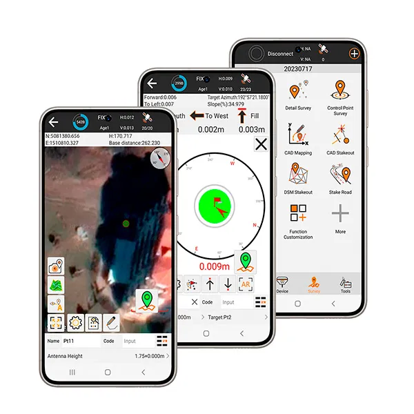
Record point survey, detail survey, and control point survey data with configurable limits for solution status, HRMS, VRMS, PDOP, and smoothing.

02

Point, line, and CAD stakeout

Stake out points, lines, and CAD entities with directional guidance, nearest-point workflows, intervals, offsets, and drawing-based selection.

03

CAD mapping workflows

Import DXF and DWG files, manage layers, draw geometry, and use CAD calculation tools directly in the field.

04

Road design and road stakeout

Work with centerline, vertical profile, broken station, standard cross sections, widening, superelevation, and slope data for road projects.

05

Coordinate systems and localization

Configure coordinate systems, projections, datum parameters, horizontal and vertical adjustments, localization from control points, and grid-to-ground corrections.

06

Field calculation tools

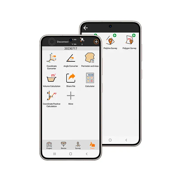
Use coordinate converters, area and volume calculations, inverse and forward calculations, intersections, resection, vectors, offsets, and more.

Why surveyors choose X-Survey

  • One Android app for daily field work
    Project management, GNSS communication, survey, stakeout, CAD, and tools are organized in a practical workflow.
  • Flexible hardware compatibility
    Supports a wide range of GNSS RTK receivers, Total Stations and works with Android tablets and smartphones as controllers.
  • Built for configurable field operations
    Users can customize function menus, settings, shortcuts, data formats, code libraries, and coordinate workflows.

Typical usage areas

  • Surveying and topography
    Point collection, control surveys, staking, and coordinate management.
  • Construction layout
    Point, line, DSM, and CAD stakeout for practical field positioning.
  • Road projects
    Road design inputs, cross sections, and road stakeout workflows.
  • Power line workflows
    Electric line survey and electric tower stakeout are included in the survey module.

Clean interface, field-ready tools

Real app screens for survey, stakeout, and field tools

Trial and activation

Simple licensing flow for demo and full use.

1
Install the APK on your Android device
On first installation, the device receives a 30-day trial period.
2
Use the trial to test your workflow
After the trial expires, the software asks for an activation key.
3
Activate the full version
A valid full activation code removes the usage limitation and sets the expiry date to 2999-12-31.
4
Important note
The same device cannot receive the 30-day trial repeatedly after reinstallation.
X-Survey land surveying software

Download DEMO X-Survey

Install the APK and test the app with your equipment

Recommended for testing with compatible GNSS RTK equipment and your Android controller.

Get X-Survey full version

Buy once, use without limits. Compatible with a wide range of GNSS receivers and total stations.

X-Survey DEMO Version

Free

Try X-Survey in real field conditions with a full-featured 30-day trial.

  • Full access during the trial period
  • Test with your GNSS RTK equipment
  • One trial per device
Download DEMO version

Need help first?

Contact

Use the contact form or message directly in WhatsApp for questions before purchase.

  • Compatibility questions
  • Activation guidance
  • Pre-sale support
Contact

Contact

Send us a message directly via WhatsApp or use the form below to get in touch.

X-Survey land surveying software

X-Survey

Android surveying software for GNSS RTK and total stations
Contact
Available via WhatsApp
Support
Contact us for licensing, compatibility questions, or technical assistance.